Showing posts with label spot. Show all posts

Wednesday, December 21, 2011

See You on the Flipside

usaplogolargeToday marks the 2011 Winter Solstice which means the days are getting longer in the U.S., but in my case, the days are about to get much longer. Rather than a paltry 10 hours of daylight per day, starting today I am embarking on a journey that will be providing continuous, 24 hour-per-day sunlight! If your physical geography lessons are still fresh in your mind, then it won’t be too difficult to solve the puzzle of how I am about to affect this change. That’s right, I’m going to Antarctica!

It is going to be a topsy-turvy trip akin to Alice’s fall down the rabbit hole during which my 24+ hour travel will result in a complete loss of a calendar day (only 364 days in 2011 for me) and an almost immediate transition from winter to the Austral summer where I will be hanging by my feet upside down on that quirky side of the planet. Apparently, our old friend Coriolis will make the toilets flush backwards and the sun will traverse the sky counter-clockwise. It truly will feel like a upside down, mixed-up Wonderland.

This incredible opportunity presented itself this summer when my friend and colleague at LASP, Lars Kalnajs, asked if I might be interested in joining him and another friend and colleague, Sam Dorsi, on a campaign to install and test ground ozone monitoring stations in remote locations on Antarctica. First off, if these names ring a bell, it’s because these two guys are the same characters with whom I launched 3 balloons to the edge of space in 2010! One of the most important lessons I learned from those adventures is the incredible importance of working well with others in challenging situations; and I knew that if I had an opportunity to work with them again in the future, I wouldn’t blink an eye. So when this proposal was put on the table, my answer required no deliberation: Of course I wanted to join this expedition to the far reaches of the Earth!

The details of this scientific enterprise will be addressed in future posts, but I’m sure you’re wondering where exactly we’ll be going, how long we will be going, etc. Our research campaign will be based out of McMurdo Station which is the largest such research station (~1000 people), which by extension also makes it the largest settlement in on the continent, since Antarctica is a continent of science only! The launching point for McMurdo is 6 hours north in Christchurch, New Zealand, but international flights only go to Auckland on the North Island of NZ which are 14 hours from LA which is 3 hours from Denver. As you can see, it is quite a journey just to get to Antarctica, but compared to the epic journeys of the early polar explorers, this trip is a breeze. The additional complications of the holiday season helped dictate a slightly early departure from Denver with the added benefit that we will get to explore a sliver of New Zealand over the Christmas weekend before getting down to business on the icy continent. After the quick holiday, we will hop our flight down to Christchurch where we will deal with the final logistics before boarding a C17 military transport on December 28th for the actual flight to the ice. Upon arrival at McMurdo, more logistics and training will ensue before we can finally begin our work in earnest. We will then spend 5 weeks preparing the ozone instrument stations and deploying one per week in remote locations in the vicinity of McMurdo. Then finally in mid-February after the scientific campaigns have been completed, we will fly back to Christchurch where I will vacation with the Kiwis for a few weeks. Finally, in mid-March I will return home to Colorado.

My departure from Denver is imminent, and I must admit that the build up to the trip is like nothing I have ever experienced. I have pored over books and movies of the great white South, and have pictured myself a thousand times on the exotic continent of Antarctica. In my mind, this is the trip of a lifetime and is like going to the Moon or Mars to me. And like the pioneering polar explorers, the Apollo astronauts, and the Mars rovers, I aim to document my experience to my full capacity. My gear packing is short on clothes, but long on electronic gadgets. I have no fewer than 6 GPS devices, 5 cameras, 2 panoramic time lapse rigs, and a fully autonomous unmanned aerial vehicle (UAV) with onboard video that I will be exploiting to the fullest to capture my experience of Antarctica. This adventure will certainly be the essence of my website title as I share my stories and explore technological means of sharing those stories.

Although I am skeptical of its performance in Antarctica, I will be checking in periodically using my SPOT Messenger which will update the map below. So sit back, sign up to follow this blog (top right of the webpage), and enjoy our expedition from your favorite easy chair!

Thursday, December 2, 2010

Costa Rica Kayak Adventure!

Tomorrow, I take off for a 10 day whitewater kayaking adventure through Costa Rica! The warm weather will be a welcome break from the cold winter that has begun to descend on Colorado, and it will feel great to get back in my kayak every day after a dry spell with almost no boating. Rain and flood conditions tend to dictate which rivers are navigable on any given day, so there is no set itinerary for our trip. However, I plan to check in with my SPOT GPS each day so you can follow along from your computer. I can't wait to get started!

12/3/10- 5:09am Barely got our kayaks onto the plane. "Continental Airlines will accept one pack containing a lightweight assembly kayak less than 50 lbs ". No size restrictions mentioned or any mention of hardshell vs. collapsible. We were second in line at 4am, but the agent said there was a luggage embargo for large items and that our kayaks didn't qualify as "kayak assembly". Not cool. Fortunately, I kept my cool and after 20 minutes, I was able to convince the supervisor to let the boats on the plane. Whew. Now I'm just hoping they make it to Costa Rica.

4:31pm Made it to San Jose and the Hotel Mi Tierra and sent my first SPOT update. Now I'm updating my blog from my iPhone over wifi in the hotel. Very cool use of technology! And just as importantly, our kayaks and gear all made it here successfully. Pura Vida!


12/4/10 7:00am The whole crew made it here and we are off to run the Sarapaqui and possibly a 30 foot waterfall! Bueno!


7:55pm Awesome day on the Lower Sarapaqui. Lyle was the only one to run the 30 ft waterfall, since he broke his paddle on the descent. The jungle setting and warm water were huge contrasts to my normal Colorado boating style and very cool. Exhausted.

12/5/10 8:41pm Another incredible day in the Sarapaqui. This time we did the Upper and Lower. I could really get used to boating every day down here. It doesn't get much better!

12/6/10 6:30pm Kayaked the Upper and Lower Pejibaye today. Very cool jungle setting with huge boulders and trees hanging over the river. Big 6' drop to start things out and then slow going to avoid strainers among the boulders. We all had a great time and are now staying in the beautiful Turrialtico lodge just outside of Turrialba. Tomorrow we begin an overnight on the Pacuare, so no internet but SPOT should hopefully work, and of course the kayaking and scenery will be incredible.


12/7/2010- 9am, Change of plans. It rained all night which resulted in the Pacaure swelling up to the red gauge. So rather than chance it, we are heading to the beach for a few days. Either way, it's hard to beat!

12/8/10 8:30am. Dawn patrol kayak surf session this morning at Playa Hermosa. Now off to kayak a river. Awesome!


6pm. Kayaked Upper and Lower Naranjo. Another cool run and even had a crocodile chase Lyle!
Now we are staying in Dominical beach town for a few days. The black sand beaches have amazing phosphorescent organisms that light up like stars when you kick sand in the dark- trippy!


12/9/10 6:30pm Just got out of my boat for the last time today. It's really amazing how much time I have spent in it this week! Today, we started kayaking in a tiny mountain creek that led into the clear waters of Rio Guabo that eventually led us into the Pacific Ocean. Source to sea- how incredible! Along the way, we had shelf drops, waterfalls, a poisonous snake, a crocodile, and then 6' breaking waves in the ocean. And then we surfed our way back along the beach to our hotel. After a short break, we were back in the ocean ripping up the waves in front of an amazing sunset! Finally, darkness got us out of our boats and back to the hotel for a shower and dinner. Man, what an incredible vacation!

12/10/10 6:30pm. Living the life in Costa Rica. In the ocean at 5am for 2 hours of kayak surfing as the sun rose, then kayaked the middle section of Rio General, then back in the ocean for the last hour and half of the day for more kayak surf as the sun set over the Pacific.

12/11/10 10pm. How many days can I report on another great day here in Costa Rica? Dunno, but today will be my last until my next visit :-( Today began with another dawn kayak surf session followed by banana pancakes and then kayaking the Rio Savagre. What an amazing trip!


Finally put together a photo slideshow and posted it to YouTube!


Tuesday, June 29, 2010

Tour d’Ark Follow Along

This Thursday morning, I will begin 5 days of whitewater kayaking with several friends down the Arkansas River in Colorado starting on the Granite section and ending in Canon City almost 100 miles later. The trip was dreamt up by Scott Winkleman as a perfect way to see all of the whitewater sections of the Arkansas River that we all usually kayak as day trips, but instead as one long, mulit-day, kayak-self-support adventure. We will be meeting friends along the way to share different stretches with us and hopefully provide some dinners, but we will carry all of our camping gear in our kayaks throughout the trip. It is sure to be an unforgettable journey, and you can follow along from the comfort of your living room by checking on the live updates on this map from my SPOT GPS this Thursday through Monday.
Happy July 4th!

Thursday, June 17, 2010

Gates of Lodore Follow Along

On Saturday, June 19, I will embark with my friends on a 4 day whitewater trip down the Green River through the Gates of Lodore in Dinosaur National Monument! This is a wonderful trip through desert country in northwest Colorado that is sure to be a good time! As I've done in the past, I will update our remote location using my SPOT GPS messenger beacon, but I'm going to try using the real-time tracking with 10 minute location updates on this trip.  Check back here on the map Saturday through Tuesday to monitor our progress as we wind our way down through the remote desert canyons on the Green River!


Or you can check our location on the SPOT webpage.

Friday, April 16, 2010

History Balloon Photos

High Altitude Balloon Flight for Boulder History Museum I would have to say that recovering the balloon package is my favorite part of launching high altitude balloons. The whole process reminds me a bit of playing neighborhood baseball as a child. Inevitably, the ball would get hit into another neighbors yard or get caught in a tree or someplace inaccessible, and then a small adventure would ensue as we went about trying to get it back. As we get older, our sense of scale and focus changes, and we find less and less wonder in our usual, immediate surroundings. But every time we launch one of these balloons, eastern Colorado suddenly becomes my childhood neighborhood as I set out to search for the camera package with my friends. And every time, it is an adventure.

High Altitude Balloon Flight for Boulder History Museum We do our best to select launch sites and wind conditions that will provide a safe trajectory away from heavily populated areas and airspace. And we label the camera package with our contact information and non-hazardous markings. But even with all that, things don’t always go to plan and we end up confronted with a situation like this!

It turned out that the balloon package landed in a horse corral and the shredded balloon covered the “Non” portion of the “Non-Hazardous” marking. Within 20 minutes of landing, two nice women noticed it and called the police due to the suspicious hazardous markings. Thanks to our trusty SPOT messenger, we made it there before Johnny-Law, and as Ricky Ricardo used to say, we had some esplainin’ to do. We happily shared the purpose of the mission and the joy that we witnessed when the balloon was launched in front of dozens of elementary and middle school children. We even dismantled the package to prove to the officer that we were on the up-and-up, which was sufficient for him to continue on his way. And we finally reviewed the photos with our new friends and promised that we would follow up with an email link to the photos.

HistoryAltSpeedA  closer examination of the GPS log showed that the balloon reached a new personal record of 109,000 feet above sea level! Be sure to check out the GPS track file with geotagged photos and the photo album of the best photos.

A Historic High Altitude Balloon

This morning will mark the third flight of the camera/SPOT balloon package to the edge of space in 2010. The flight is another education and public outreach (EPO) opportunity that is taking place in conjunction with the Boulder History Museum. They are working with a local middle school to film and produce a short documentary about scientists in Boulder and Lars and the atmospheric scientists at LASP fit the bill. Or maybe they just wanted some cool pictures of the edge of space. Anyway, below is the map that will update automatically with the balloon’s location after its 9am MDT launch. Enjoy!

UPDATE: This launch even got a press release in the Boulder Daily Camera newspaper!

Wednesday, March 24, 2010

Lucky Balloon!

St Patrick's Day High Altitude BalloonIf you read the pre-flight article, you’d remember that I ended by saying, “Let's hope for the Luck o' the Irish for the ole' balloon!” As it turned out, this balloon flight definitely needed the luck of the Irish. After a perfect launch into a blue-bird Colorado sky, we casually began to follow the SPOT location updates from the balloon towards the expected southeast landing location. Things were going great, almost too great. We followed it to Kiowa, CO and surmised that it must have been descending based on the time aloft and SPOT update cadence after its high altitude blackout. An impromptu picnic ensued on a prairie hillside while we waited for another SPOT update, but it never came. After half an hour, we decided to continue driving and search for it roadside, but that only got us as far as the Sproch Cemetary for another wait and rest session. But there would be no more updates from the SPOT. It was a beautiful day and we were enjoying ourselves, but it was difficult to accept that the balloon was lost and we might never know why it fell off the radar. After verifying with SPOT tech support that there servers were still functioning, we did another slow road side search while driving back to the last known location. A local rancher allowed us on his land and we fanned out looking for a needle in a haystack, or in this case, a camera in a hayfield. It was amazing how many small objects appeared to be the balloon, its parachute, or the styrofoam package. And there was always one more hill just over yonder that might have hidden our treasure. It was like wandering the desert and coming upon mirage after mirage. We probably walked about half a mile before realizing the absurdity of our search and heading home.
Several days came and went along with spring snow which I realized would have ruined the poor camera as it sat out in the elements. What a sad fate for the tough little Canon SD800. Two trips to the edge of space and then a snowy demise.
St Patrick's Day High Altitude Balloon Even then, we all held hope that some day several months in the future, a farmer would stumble upon it, give us a call, and we would at least be able to recover the photos on the SD card. What I didn’t expect is that I would get that call on Monday, only five days after losing the package! Our luck had certainly changed for the better, and I immediately drove down to Castle Rock to retrieve the camera package!
St Patrick's Day High Altitude Balloon It turns out that the package landed less than a mile from the last SPOT update and that if we had kept searching in the same direction, we would have probably found it within 30 minutes! On Thursday evening (the day after the flight), a local rancher was out gathering her cows when she came upon it. She brought it inside that night where it sat warm and dry for the next several days as the wet snow blanketed the fields outside, and then she contacted us on Monday. I couldn’t have been more excited when I got the call about it! I literally jumped up and down in my office and hooted and hollered. I exclaimed that it was better than winning the lottery! It didn’t take long to reach Castle Rock where I offered my sincerest thanks to the rancher for her kindness and honesty in getting the package back to me.
speed_alt Once again, the photos from the edge of space were absolutely beautiful with expansive views of the snow capped Rocky Mountains and an amazing overflight of Denver. This payload included more sophisticated instrumentation including a dedicated GPS data logger and a separate Arduino-based logger of GPS information, heading angle, pressure, and ambient temperature. As expected, the EM406 GPS on the Arduino did not function at high altitudes, but the Sparkfun GPS logger kept on working and recorded a new altitude record for us of 106,000 feet above sea level!
Of course, we have lots of terrific photos in this Lucky Balloon photo album and an accompanying KMZ file to view the entire flight with geotagged photos in Google Earth.
St Patrick's Day High Altitude Balloon But the question still remained, why did the SPOT stop sending us position updates? Well, when we opened the package, its LEDs were still blinking in the correct mode, so we know that it was still powered on. We also know that the reentry speed was much higher than the first flight and a hard landing could have possibly caused a glitch. But most importantly (in my opinion), we know that it landed on its side in an open field with a clear view of the sky, and we know that SPOT recommends that it be operated with its antenna facing up and with at least 12 inches separation from any other GPS receivers. So it’s my belief that the combination of radio interference with the other electronics and the poor viewing angle to the sky caused us to sweat it out for five days until our guardian angel delivered the camera back to us. Hopefully, we learned our lesson and won’t need to rely on luck next time!

Tuesday, March 16, 2010

St Patrick's Day Balloon Launch

That's right, the balloon team is back at it again! This time, we are launching a balloon as part of an Education and Public Outreach (EPO) effort at LASP in conjunction with Arvada High School. The expected launch time is 9:30am MDT.

The payload has a few extra goodies this time based on the open-source Arduino microcontroller platform that should simplify data logging of GPS location, heading, pressure, and temperature. We will still be taking photos once per minute and tracking the real-time location using the SPOT satellite messenger.

I will be attempting to provide some real-time video streaming of the launch, chase, and recovery from my iPhone using a free service from USTREAM. Check out the embedded video below, or if you want to view it in a separate browser window go to this address.
Once again, check the map below for the balloon's location that will be updated every 10 minutes, or you can view the progress at the SPOT Shared Page or at the SPOT Trip Manager page.


Let's hope for the Luck o' the Irish for the ole' balloon!

Thursday, January 7, 2010

Edge of Space Follow-Up

The expanded analysis of the January 5 balloon flight to the edge of space is finally available! If you aren't a geek, you will be probably be satisfied with the YouTube documentary and photo albums that are presented below. But if you have been asking questions like, "How high did it go?", or "How come the camera didn't get too cold and stop working?", then you should keep reading after the fun multimedia shows.

 
If you enjoyed the movie and want to browse through the photos at your own pace, be sure to check out this annotated photo album.
 

Now it's time to get down to geek business...

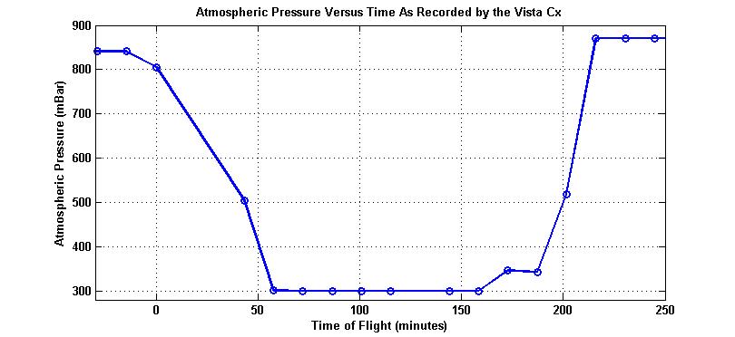
The number one question I have been asked has been, "How high did the balloon go?" In order to answer this question, we flew my Garmin Vista Cx that logged GPS location every 5 seconds and also logged barometric pressure/altitude. I configured the GPS to use the pressure in the altitude calculation, since I had heard rumors of consumer GPS not working at high altitudes. However, upon recovery we were disappointed to discover that the barometric pressure saturated at 300 mBar (30k feet) and the cadence was very slow (~15 mins/sample).
 
The saturated pressure resulted in a GPS profile that maxxed out at 30,000 feet. However, the rise rate up to that elevation and the descent rate had great fidelity, so there was hope at estimating the maximum altitude. Finally, the photos were taken at regular 1-minute intervals, and the images showed clearly when the balloon popped, since they began to tumble irregularly. So with a little engineering detective work, I was able to estimate the maximum altitude at 93,687 feet as seen in the plot below!
 
Another interesting lesson we learned regarding altitude was that the SPOT does not provide altitude in its location reports. Because of that, when we received updates near the predicting landing site at Limon, we assumed that it was on its way down. We spent several minutes looking up in the sky, only to learn much later that it was at its apex at that time!
 
Garmin MapSource software was used to determine the speed of the balloon throughout its trajectory based on the time-tagged GPS locations. The plot below shows that the speed was at its maximum when it was traveling in the jet stream. However, the maximum speed was not properly reflected, since the vertical component during free-fall was not part of the GPS data.
 
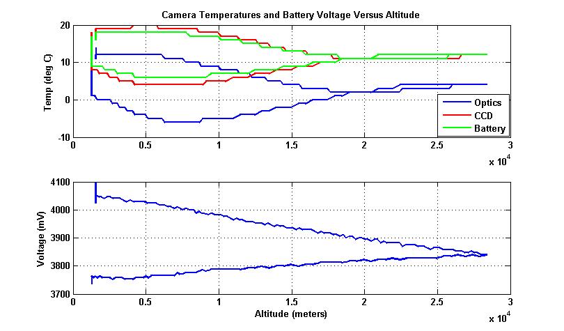
The other question that has been asked frequently has been, “How did the camera not freeze in the cold upper atmosphere?” First off, we packaged it in a styrofoam container that helped to maintain a warm environment, and secondly, Lars built a resistive heater using two 9volt batteries. But still, we didn’t know how things would turn out. However, Sam discovered that in CHDK, he could log temperatures in the camera, so that if it did stop working during the flight, we would know what conditions caused the problem. He was able to configure the SD800 to log the temperature of its optics, the CCD sensor, and the battery, as well as the battery voltage every minute when the photos were programmed to be taken. Additionally, he created a low-power mode (3.7volts) that would take photos less frequently. As previously said, the camera was still operating when we recovered it which was a testament to his programming and the camera itself! The plot below shows that the coldest portion of the camera was the optics housing, which wasn’t surprising, since it was exposed to the outside environment. We were pleasantly surprised to see that camera stayed relatively warm throughout the flight and that a heater may not even be needed if we need to save weight in the future. You can check out a plot of the temperature versus altitude here and try to explain to yourself the reason for the temperature at the apex of the flight.

All of this data is really fun, but questions kept coming up when looking at the photos. People would ask, “How high was it in this photo?”, or “How fast was it traveling in this photo?” Since I had the times of all the photos and time tagged data, I was able to correlate the two and ultimately insert the data into the description field of the IPTC header for each of the photos in this album.
 
balloon_GEFinally, with the newly predicted altitude, I was able to modify the GPX files and incorporate the predicted profile into Google Earth. That profile was then used with RoboGeo to geotag the annotated photos to create an interactive experience in Google Earth that provides a comparison between the predicted path, the measured path, the extrapolated path, and the SPOT update locations. And to top it off, satellite cloud imagery was overlaid in order to show correlations between the camera photos and the satellite photos! (SpaceBalloon140.jpg, 215, 225, 232 shows the blob cloud with the same perspective as the weather satellite photo overlay.)  You can get the KMZ file here.
 
Or if you don’t want to view the photos in Google Earth, you can always check out this Google map in Picasa with geotagged photos instead.

You would think I was done with this data-rich, multi-media interpretation of the balloon launch, but I also decided to publish a Blurb book with the best photos from the album. After all, this website is all about digital stories, right? Click on the link below to preview or order the book.
 
I hope you’ve enjoyed this experience. I know I have and I look forward to more balloon launches in the future!
 

Photo Album

Blurb Book

Youtube Documentary Video

Google Earth Track with Photos (KMZ file)

Monday, January 4, 2010

Going UP Tomorrow!

UPDATE! 9:36am- Up, up, and away!

Tomorrow morning at approximately 8am MST, a weather balloon with my modified Canon SD800is, my SPOT GPS transmitter, and my Garmin Vista Cx will voyage to the edge of space!

The idea belonged to my colleagues Sam and Lars, and was soon added to my list of resolutions. After realizing that it was a reasonably easy goal to accomplish, we set about gathering all the parts and preparing to launch the camera to 100,000 feet above the Earth. For comparison, jet airliners fly at 35k feet and at 100k feet the curvature of the Earth and the darkness of space become apparent. Our goal is to photograph this breathtaking sight and return our payload safely to earth using off-the-shelf components that we already have. The camera was modified using the Canon Hack Development Kit (CDHK) to take photos at regular time intervals. The GPS will record the 3D path of the balloon as it ascends through the atmosphere, into the fast moving jet stream, and finally above 99% of the atmosphere where it will expand to a point that its latex surface will rupture. The payload will rapidly descend through the upper atmosphere until the air density increases to the point that the attached parachute slows the descent to a safe speed to its landing location about 100 miles downwind from the launch site. And all the while, the SPOT will be relaying the position of the balloon to us in real-time!

So if you are interested in following along, just take a look at the map below and be sure to refresh every it 10 minutes or so. I can't guarantee the exact launch time, so keep checking our progress throughout the morning.

Monday, June 22, 2009

Middle Fork of the Salmon River Follow-Along

Check back at this post each day to see the progress we've made as we raft and kayak our way down the Middle Fork of the Salmon River!

We launch on Friday, 6/26, take out on Thursday, 7/2, and will then kayak for a few days near Jackson, WY before returning to Colorado.

Update 6/3/09: We are safely off the river after a fantastic week of boating! No more updates to the map from now on.

Monday, June 23, 2008

Wyoming vacation follow along


Richele and I head up to Wyoming this Friday for a little over a week of backpacking, kayaking, and playing in the Yellowstone/Teton National Park region. If you are interested in where we are, I will be checking in with my Spot satellite messenger (see previous post) on a daily basis, so you can see whether we are car camping or hiking near grizzlies, bison, and geysers in the Yellowstone backcountry. Just check out my Spot map page to see our recent locations.

(Note: The Spot site was down as I wrote this, but I hope it will be active by the time the trip begins...)

Thursday, May 1, 2008

SPOT Satellite Messenger

Another GPS based device I recently acquired (also thanks to my REI refund) is the SPOT Satellite Messenger. It is generally considered a sort of personal locator beacon (PLB), but those who know better quickly point out that it is based on completely different technology, so it is really in a category of its own.

I got to use it for the first time in earnest when I rafted the Green River through Desolation and Gray Canyons two weeks ago with John Leventhal. Thankfully, even when I choked on a Triscuit, there was no need to use the emergency 911 feature that would have notified a 911 dispatch service of an emergency at our location. However, I did use the OK Check-In feature on a daily basis. I had set up a list of 10 email addresses of friends and family who I thought it would be fun and/or useful to check in with throughout the trip. I should mention that as the name of the canyon implies, it is extremely desolate in this part of the country and there is no hope for a cell phone signal while on the river. But since SPOT sends its text messages via the Globalstar satellite system, if the unit is in North America or Europe and has a clear view of the sky for sufficient time, it should be able to send out a message even where cell phones have no hope.

Each day when I arrived in camp, I would turn on the SPOT, press the OK button, and leave it for the recommended 20 minutes with a clear view of the sky. And each time, it dutifully sent a message to my friends and family that looked like this:
We are safe and having fun rafting Deso/Gray on the Green River! Will try to check in tomorrow! See you soon!
ESN:0-7368439
Latitude:39.6595
Longitude:-109.9886
Nearest Location: Fairbanks Crossing, United States
Distance: 23 km(s)
Time:04/14/2008 19:26:59 (US/Mountain)
http://maps.google.com/maps?f=q&hl=en&geocode=&q=39.6595,-109.9886&ie=UTF8&z=12&om=1
Everyone commented that it was fun and reassuring to see our location, but they all also said that it was unfortunate that they weren't able to monitor our progress from one day to the next by seeing each day's waypoint on a common map.

That being said, there was a way to view all the waypoints on a common map, but it left a lot to be desired. I was able to view all my waypoints on the SPOT website like the image below, but I had to enter my username and password that was also the same one that manages the rest of my SPOT account including my credit card information. I obviously wasn't going to hand out my personal information to everyone I knew, so this feature was essentially non-existent. What was needed was something similar to my Blogger account or my Motionbased.com account, both of which allow me to share my information with either a selected group of people or the whole world.


Well low and behold, as I write this I find out that all the customer requests to SPOT for a shared page has been answered! My shared page can be seen here. Unfortunately, it is only trying to display messages from the last 24 hours, so my Deso/Gray trip isn't visible. Hopefully, this will be fixed soon and I can provide an update on how useful the sharing is. Till then...