 After some trial and error, I have a nice method of recording GPS data on multi-day trips that is useful both during and after the trip. I typically use this procedure on backpacking, biking, and rafting trips when I will be sequentially moving from one location to another. In these case, I like to know how far I have traveled in total as well as my mileage for the current segment of the trip.
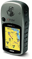
This procedure is based on the Garmin eTrex Vista Cx that contains a microSD expandable memory card. The card can be used to hold topographic and street maps, as I described in this post, and can also be used to store track data. This turns out to be a very useful feature, since the built in capability to save maps is inherently flawed for a few reasons. First off, the available memory for saved tracks is limited to the built in memory, which may not be sufficient for longer excursions. Second, the tracks are saved in a Garmin proprietary format which requires Mapsource to extract them and then convert them to GPX format. Finally, and most importantly, the process of saving tracks results in truncated data. The time of each waypoint within the track gets deleted which makes geotagging photos impossible, and some people have even reported that waypoints get deleted.
Hopefully, I have convinced you that it makes more sense to store your tracks to the microSD card! So let's get started!
- Make sure you have fresh batteries. I replace mine every 2-3 days when used for 6-8 hours per day to make sure I don't have any data drop outs.
- In the GPS go to Main Menu->Tracks->Setup->Data Card Setup and enable the "Log Track To Data Card" option.
- Enable track logging, by choosing the "On" option at Main Menu->Tracks. One of the nice aspects of this procedure is that you do not need to manually save or clear your tracks each day the way you would need to if you were using the built in memory. I should mention that there is an undocumented bug that can ruin your GPS if you clear the track log when it is turned off. I did this and it completely destroyed the software on the unit. Fortunately, Garmin sent me a replacement for free.
- I primarily use the Trip Computer page to monitor my trip progress in real time. As I previously alluded to, each day I make sure to reset the Trip Odometer on the Trip Computer page, but I do not reset the Odometer. This provides real time monitoring of the distance for each day and the entire trip.
- I mark each day's camp and other significant locations with waypoints on the GPS. A very quick method of marking a waypoint is to press and hold the 5 way rocker key. Often times, I just press okay rather than laboriously typing in a description for the waypoint.
- Finally, I carry a small notebook that I jot down the locations I have traveled each day, the names of camps, and descriptions of interesting waypoints. I find that this makes adding descriptions to the GPS data much easier and more accurate when I finally get to looking at it back home.
That's it! And after I have all this data and I've returned home, I go ahead and process it into a single GPX Trip file. But that's a topic for another post!

No comments:
Post a Comment